East Anglia is an often-forgotten treasure trove of history and archaeology. As the area surrounding the second city of England for many centuries, many important events have taken place across our lands. It is even thought that East Anglia might have been important to even prehistoric people, with our abundance of flint and being the gateway to the country over what used to be a landbridge to Europe called Doggerland. Thankfully for historians, we can bypass the possibly biased sources from chroniclers at the time and look at the physical footprint left by each event via archaeology. But where are the best archaeological sites in our fine region? Well we have selected a few of the more famous ones below, all of which you can visit today!
Sutton Hoo
Starting with Suffolk, our fellow East Anglian county to the south holds one of the most famous British archaeological sites. Made popular by the 2021 film The Dig, Sutton Hoo also plays host to one of the most important Anglo Saxon archaeological sites in England dated to around 625CE. The site was discovered in 1938 by self-taught archaeologist Basil Brown on the land and under permission of Edith Pretty. He found two Anglo Saxon cemeteries linked with the ancient kingdom of East Anglia with an undisturbed ship burial. The Anglo Saxon ship burial was like that of many sea-faring peoples where the ship is carried ashore and buried upside down over the deceased as a makeshift tomb with many lavish grave goods in the graves of important people. It just so happened that the one discovered by Mr Brown belonged to a King – Raedwald of the Wuffinga royal family. In Britain, only three boat burials have been discovered so far and two of those are at Sutton Hoo.
Inside the mounds in the landscape, many incredible and now famous artefacts were found, including a plethora of metal dress fittings filled with gold and gems, a shield and sword, a lyre, a silver plate thought to be from the Eastern Roman Empire and most famously the incredible helmet that has become their logo. In total, 263 discoveries were made. Boat rivets discovered throughout the plot were pretty much all that was left of the boat except for the shape engraved in the soil. Sadly, due to the acidity of the soil, no human remains of the ancient king were discovered, his bones having now dissolved into the ground. On top of this, it seemed as though 17th century treasure seekers had found the site before them, ransacking many of the tombs, taking the artefacts, melting them down and sharing them with the crown. Despite this, at least two tombs were missed by the looters and left untouched, leaving archaeologists with a different kind of treasure, a direct line to the original Kings of the land.
For poor Basil Brown, however, the importance of the site led to him being removed as the lead archaeologist as national scholars scoffed at the idea of a working class individual being the one to lead such a discovery. Other digs have taken place in the 1960s and 1980s as archaeologists widened the field they were digging in. In the late 80s/early 90s, archaeologists made a more gruesome discovery in a sandy area nearby of 39 bodies, all of which were found bound and to have died a violent death with many showing signs of broken necks and decapitation. They’ve been dubbed the “sand bodies.” Nearby postholes led historians to believe this was the site of the gallows used by early Christians to dole out death and punishment on criminals or those who would not follow their new religion. It is possible that this is why they chose the old burial grounds of pagan kings as a place to perform these executions.
Today, Sutton Hoo is a popular visitor attraction, offering guests the chance to explore the burial mounds themselves, view the site from a tall viewing tower and explore the museum full of artefacts and the house of Lady Edith Pretty.
Grime’s Graves
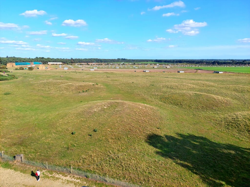
If you were to come across the site of Grimes Graves without knowing what was there, you would most likely be confused at the almost lunar-like surface covered in several large, circular craters. What you are actually looking at are over 400 separate flint mines, dug out by Neolithic people, around 4500 years ago. The site has been an area of historical interest since around the 17th century but the first recorded excavations took place in 1852 with the main excavation and discovery that confirmed the existence of the flint mines taking place in 1868-70 under Canon William Greenwell.
The name Grime’s Graves comes from Anglo Saxon name for their god Grim, otherwise known as Woden (today better known as the viking scandinavian Odin) as they were originally thought by the Saxons to be quarries or pits made by the god. Grime’s Graves literally translates to Odin’s Quarry but the pits far outdate the early middle ages, and sit closer to the time when Stonehenge was being erected.
The flint here was formed when, 90 million years ago, a warm shallow sea covered the area with a coral reef. Over time, as many small marine creatures and sponges died, they fell to the bottom to form layers that slowly fossilised into chalk and silica, which together form flint as the bodies are compressed and mineralised. Some flint, usually characterised by a smooth, black, shiny surface, is of a particularly good quality and was vital to Neolithic people. Its quality meant that it could be knapped (the creation of blades and tools from the stone, by chipping and carving parts away,) with more precision and the tools created would last longer and keep their edge. Objects like arrows and spears, axes for woodwork, knives and even farming implements all required flint.
The pits themselves were deep and impressive, up to 13 metres (43 feet) deep and in a distinctive bell shape with a long vertical shaft down to them. Many signs of the prehistoric miners, and some that followed at later dates, were found amongst the pits. These included tools made from deer antler that were used for excavation, pottery, dog bones, chalk carvings in the walls and hearths that are believed to have been used in ritual practices. Some of the pits had been turned into tombs as burials were also discovered in a few. Mining appears to have taken place here up until 2100BC and later uses for the site include as a place of farming, pottery making, rubbish dumping and possibly settlement, although no evidence of housing has been found yet.
Today the pits belong to English Heritage and visitors can even descend down into one of the pits to see the mines themselves, enjoy the museum with many artefacts on display, and wander around the beautiful Norfolk landscape.
Burgh Castle and Caister-on-Sea (Roman settlement)
Burgh Castle and the nearby Roman settlement of Caister On Sea were part of a series of Roman forts, spreading from Brancaster at the mouth of the wash, around the south east corner of England to Portchester near Portsmouth. Other fortifications existed along the coast of what was once “Northern Gaul” but is today parts of Belgium, Germany and France. Collectively the fortifications were known as the “Saxon Shore Forts”. This is due to the fact that the Notitia Dignitatum, a list of all military and civil service commands in the Roman empire, described the forts as being under the authority of “The Count of The Saxon Shore”.
Although Burgh Castle appears mostly inland today, albeit next to an estuary, at the time of the Romans it would have sat on a body of water that directly led out to sea and, alongside Caister-on-Sea, formed a defence of the Waveney Estuary. The area was important for trade and necessary for fuelling the massive Roman army that was present to hold Britain through a large portion of the iron age. Raiders were forever present along the coasts of Britain, looking to steal pieces of the enormous Roman wealth coming into the area. In some parts of the country, the Irish (known as Hibernians), Picts and Caledonians from Scotland were raiding western and northern England, but in the South East the threat came from early Germanic and Scandinavian tribes, including early Saxons who attacked more and more throughout Roman occupation. Together, Burgh Castle and Caister-on-Sea, (known together to the Romans as Gariannonum) protected the point at which the rivers Yare, Ant, Waveney and Bure meet, and the estuary out to the coast beyond from these assailants.
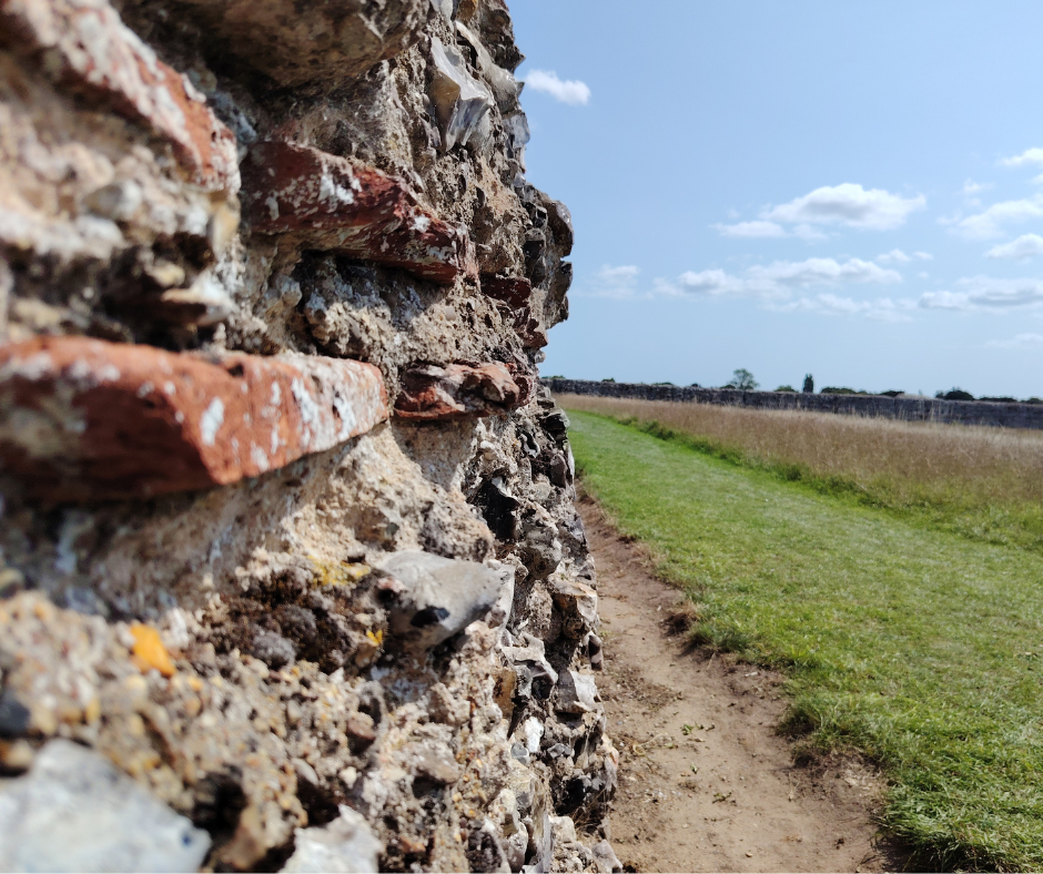
Today, neither Burgh Castle or Caister-on-Sea are complete forts. At Burgh, the main, thick defensive walls still stand, with the wall that faced the water now mostly missing. Although crumbling, the walls are still impressive to behold with some parts still reaching near to the 4.5m tall that the originals would have stood at and an impressive 11ft wide at the base. The mixture of flint and Roman brick still holds strong in parts and the inner area of around 6 acres is now filled with wild meadows attracting large numbers of insects in summer. Although we know the fort once housed the Equites Stablesiani (a unit of Roman cavalry that used their horses to quickly navigate the marshy flats around the fort,) very little evidence of inner buildings have been found archaeologically, leading some historians to believe that the inner buildings were mostly timber.
After the settling of the Saxons in Britain in the 6th century, The Saxon Chronicler Bede records in 630CE, that the East Anglian King Sigeberht gave land inside a Roman fortress to the Christian order of St Fursa so that they might build a monastery that became known as Cnobheresburgh and it is likely that this is referring to Burgh as there is evidence of Saxon occupation and cemetery but the same can also be said for Caister as well.
When the Normans arrived in 1066, they used the site of Burgh Castle to build a motte and bailey castle which they also used to protect the coastline and rivers. The bailey lay within the walls and the motte and ditch sat in the south east corner of the fort. Where the ditch penetrated the south wall can still be seen but the mound itself has long been levelled.
Caister-on-Sea is different insofar as the majority of the outer defences have been built over by modern buildings but the bases of the Roman interior buildings of the fort are on display. It was constructed around 200AD and was used to house a unit of Roman infantry and navy for the area. The interior is believed to be around 8.6 acres in size and walls of a similar height to those found at Burgh that went all the way around it. It was occupied until around 390AD which is near to when the Romans pulled out of Britain to defend their frequently besieged homeland. The area it is built on was originally a small island sitting in the middle of the estuary (most of which is now dry land taken up by modern Gt Yarmouth) and was in the perfect spot to defend the estuary from attackers.
Between 1951 and 1955, excavation work exposed parts of the south gate and the western section of the south wall as well as the bases of the aforementioned buildings. They were left open to the air and can still be seen today. The building itself was large and contained six rooms. One of these has an exposed hypocaust (underfloor heating using “vents” and stacked tiles to hold the floor above them) and the building is believed to have served many industrial and domestic purposes over time. In the 4th century, evidence suggests that the building was heavily damaged by a large fire. Archaeological finds include brooches, beads, necklaces, bracelets, rings and hairpins and point to the presence of women and children in the fort as well as soldiers, whose finds include spear and arrow heads, buckles and pieces of armour. Charred grain, fish bones, over 10,000 oyster shells and the bones of cows, hares, foxes, badgers and ducks show us what the occupants would have been eating during its occupation.
Today, both Burgh and Caister Roman forts are free to access to members of the public through English Heritage.
Seahenge – Holme Next To The Sea
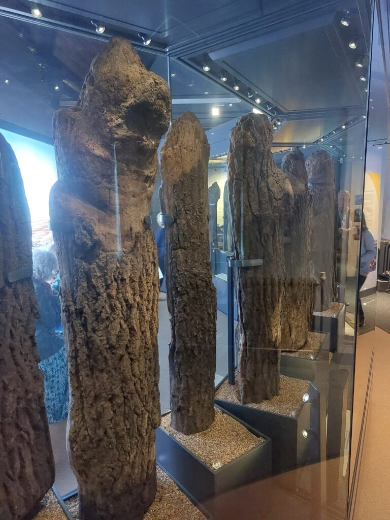
In 1998, local amateur archaeologist, John Lorimer, had discovered a bronze axe head in the sands on Holme beach and suspected that there was something more to the area. Only a few days later, he came across what was clearly an incredibly old timber that turned out to be an upturned oak tree stump. Convinced he was on to something, he contacted Norwich’s Castle Museum and before long, English Heritage were involved and an archaeological dig was started. What was uncovered was the aforementioned upturned oak stump surrounded by 55 small split oak timbers surrounding it in a ring. Amazingly, it was discovered that these timbers were nearly 4000 years old and had been placed in the area around the year 2049BC. With a similar layout to the famous Stonehenge, the site was quickly named Seahenge.
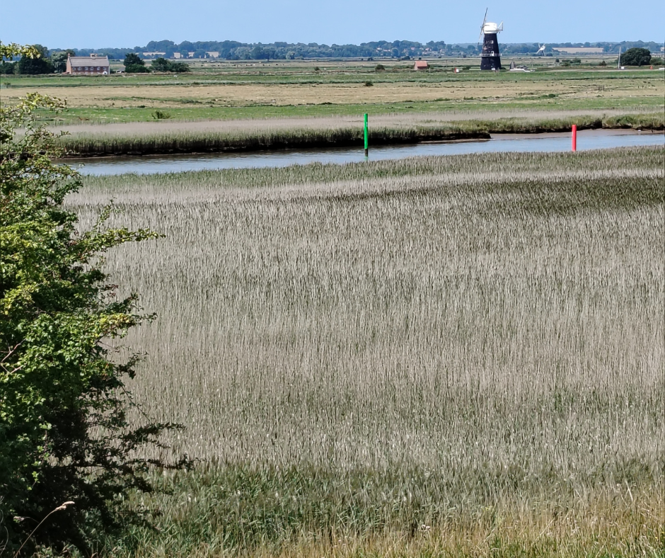
At the time of its construction, Seahenge would have sat on a salt marsh surrounded by alder trees and rushes that protected it from the sea but encroaching sea-waters due to rising sea levels and increasing storms had led to it being surrounded by sandy beaches and it was slowly being uncovered naturally. At the same time however, the seas themselves now posed a danger to the ancient timbers and could have washed them away entirely.
The purpose of the henge, like with Stonehenge, is somewhat of a mystery. Some scholars point to religious or ritual use, others a landmark and some even mention it being used for “sky burials” or excarnation. This is an ancient funerary practice in which a body was not buried or burned, but processed by removal or cutting of the flesh and the body was then left exposed to the elements for birds and other creatures to consume before the now bare bones were taken and either buried, burned or displayed. Although it sounds gruesome to modern sensibilities, it was Christianisation that led to the halting of this practice of giving back to nature. As pre Christian civilisations were often interlinked with nature, this practice fits in well with their beliefs. Sky burials are still practiced today in Mongolia and Tibet as well as some other Northern Asian cultures. Although we know this was a practice in ancient Britain, little evidence exists at the site of Seahenge to suggest this is what it was used for.
To protect the ancient monument from the sea, the decision was made by local archaeologists to dig up and remove it from the ground. This turned out to be a massively controversial decision that caused protests among locals who assumed it would be taken away from its home in Norfolk to London. Some didn’t realise the damage the sea would do to the structure over time and there were even sects of modern “druids” who protested against its removal on religious grounds. The Norfolk Wildlife Trust were also worried that the henge, if left in place, would draw large crowds and they were worried that they would pose a danger to areas of importance to local wildlife. In the end, the monument was carefully removed and parts of it are now on display at the Lynn Museum in King’s Lynn alongside a full recreation of the henge within the museum. There’s no longer any trace of the henge on Holme Beach but you can walk along a public footpath that takes you right past the site!
Warham Camp
There are a few places in East Anglia where you can look at the landscape and almost feel the history. It’s one of the draws of this beautiful region, and one of those places is definitely the dramatic earthworks of Warham Camp. Just off from the Stiffkey/Wells road, hidden in a field accessible from a public footpath, sit two, enormous concentric ring ditches, with banks rising up, still, to just over 9 feet/3 metres tall. Originally these ramparts would have been backed with timber and fitted with timber defences. It is largely believed that the fort was built originally by Boudicca’s Iceni tribe, centuries before her rebellion around 60AD, and is definitely over 2000 years old.
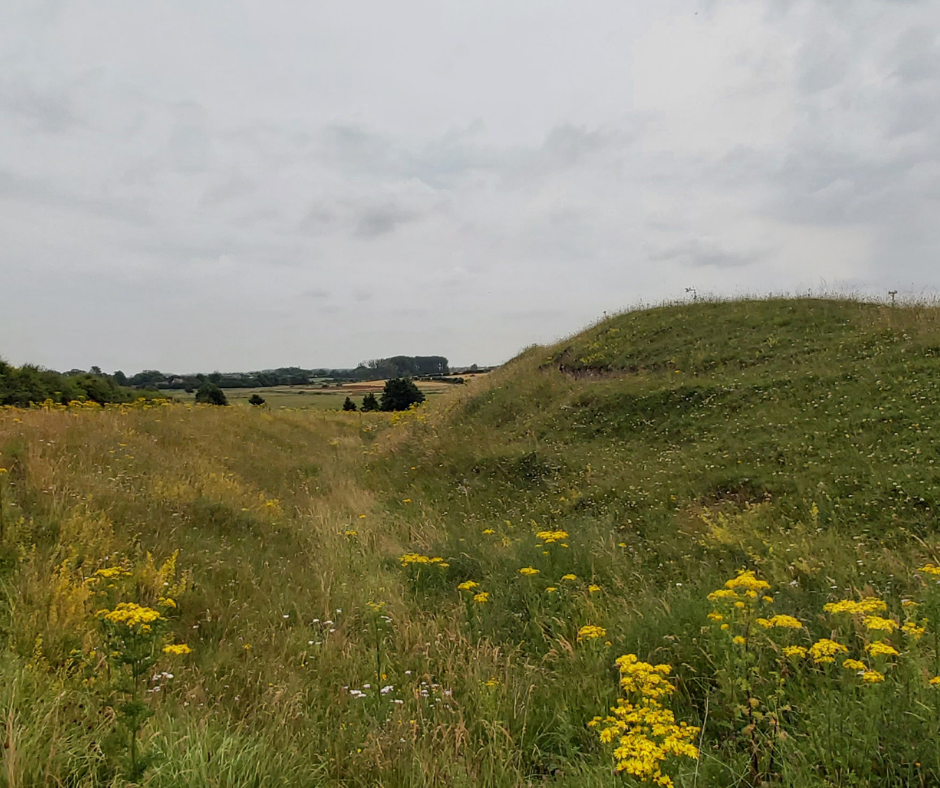
Although originally circular, the earthworks are now more horseshoe shaped due to 18th century landscaping works that rerouted the river Stiffkey (pronounced Stoo-key by the locals!) this way to improve views from the nearby Warham Grove House. The embankments were also originally probably a fair bit taller but have been lowered by the erosion that comes with time and human activity. Although it can be classified as a ‘hill fort’, technically it only sits about 15 metres above sea level, however, compared to the flat landscape surrounding it, it still commands dominating views over a landscape that has changed little in millennia.
During its original construction, it would have been visible from all around, with its now greenery smothered banks shining as white chalk in the sun. Celtic guards with their spears and oval shields would have stood guard on the walls. Today, the interior of the embankments is a sea of grass, and a Site of Special Scientific Interest as its home to the incredibly endangered Chalkhill Blue Butterfly, Brown Argus, Common Rock-rose, Pyramidal Orchid, large Wild Thyme and Quaking grass. Nearby to the site also lies Fiddlers Hill, a Neolithic barrow or burial mound which adds another element of antiquity and mystery to the site.
Scant evidence of buildings or post-holes have been found within the fortifications meaning that it’s hypothesised this was a military outpost inhabited during times of war but possibly not permanently by inhabitants. It would seem that, following the defeat of Boudicca’s brave revolt in the 1st century, that the Iceni did not return to Warham, instead now having to occupy the Roman controlled Venta Icenorum near Caistor just outside of Norwich. Evidence of Roman pottery has been found along with other detritus that points to the fort being occupied, albeit probably not for long, by the Romans themselves and it seems, thanks to a recent archaeological dig, that the Romans redeveloped the spot into a blacksmiths. It also seems as though the later Viking raiders, possibly even the Great Heathen Horde itself, occupied the fort for a time, probably using it as a safe camp in a land where all the locals were hostile to them.
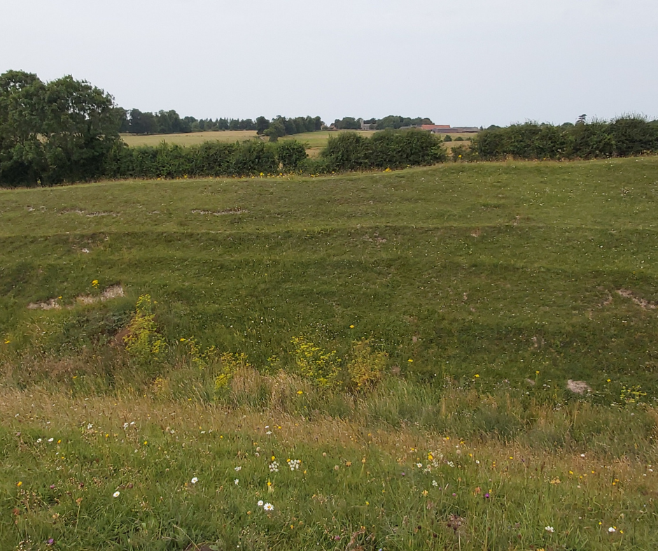
Today, Warham sits, almost lonely, in a completely rural landscape. To some, other than the earthworks, there is no real evidence of anything ancient left here, but to those who know the history, or have a good imagination, you can envision the hive of activity that once made this place so important. If nothing else, I can tell you from personal experience that it’s a wonderful place at night to go stargazing, as the lack of light pollution in the area really makes the stars and formations clear in the night sky.
Aylsham Roman Project – Woodgate Nursery, Aylsham
The final entry I have for you in this blog is an exciting ongoing dig in Aylsham that has seemingly unveiled a Roman settlement. A trial trench was placed into the land in 2015 and discovered Roman finds leading to a full dig that started in 2016 and carries on each August for three weeks. Over the time the dig has been taking place, there have been over 5000 artefacts uncovered as well as hypocaust systems (underfloor heating) , kilns and ovens and a bathhouse. The family that owned the plot of land during Roman occupation must have been one of considerable wealth and each year the site reveals more and more, pointing to a significant settlement having once existed on the land.
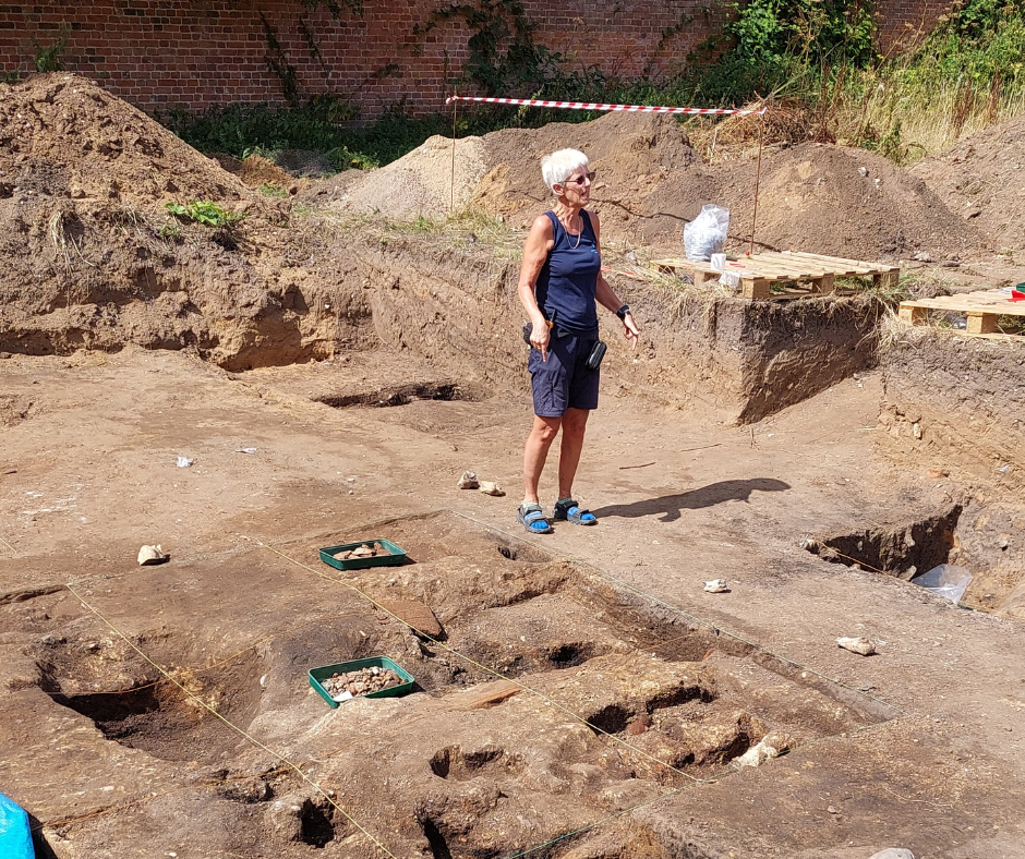
What is so wonderful about the Aylsham Roman Project is its community orientation. Volunteers from all around the local area make their way down in August to help dig, go through spoil heaps and clean finds and, as of this year in 2025, several archaeological groups have become involved, with the dig being led by Britannia Archeology. Professional archeology is mixed with local enthusiasm as locals can visit the dig during its operating times to speak to the archaeologists, see the dig and look at finds as they are found and cleaned. It really is a great way to get more people enthused about their local history. Landowner Peter Purdy and the group also keep an extensive log of the daily finds during the digs, the back-catalogue of which can be found on their website.
Just over two miles away in Brampton, was a pretty significant Roman fort and settlement and it could be that the villa in Aylsham, with its pottery kilns, made their money by trading with the settlement. Also going through Brampton was a main Roman road that led East to West through the site of modern day Norwich which would have been significant for logistics and trade.
Although evidence of the Roman buildings is still present, it appears as though most of the building materials were robbed from the site, likely by the Anglo Saxons as they started to occupy the land when the Romans left in the 5th century. Indeed ‘Aylsham’ is a Saxon name so we don’t know what the area may have been called in the centuries before.
The digs look like they are set to continue for time to come so there should be a few opportunities ahead for history enthusiasts or locals to go along and view it. Any support would, I’m sure, be appreciated by the project, as they toil away to uncover more of this incredibly exciting site!
SOURCES
English Heritage Grimes Graves
Historic England Caister On Sea
English Heritage Caister Roman Fort
English Heritage Roman Coastal Defences
Norfolk Passport Top 5 Norfolk Sites
Aylsham Roman Project Official Site